


KS-800




Product Overview
KS-800
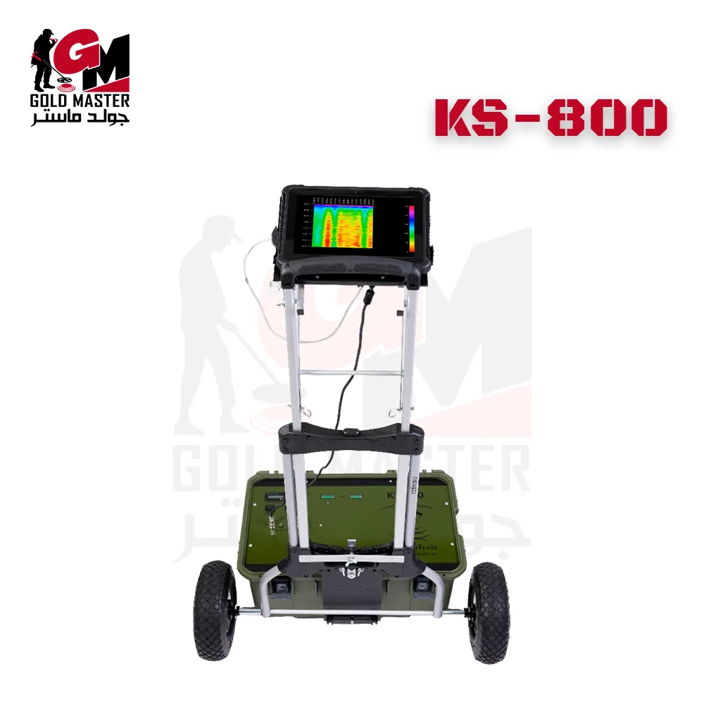
KS-800 — Professional FMCW Ground Penetrating Radar with integrated trolley and touchpad. Manufacturer-reported detection performance up to 30–60 m (site dependent), onboard 2D/3D visualization, and USB export for advanced 3D processing. Ideal for archaeological prospection, geophysical survey,s and pre-excavation site clearing.
See the Device Up Close
Product Video
The product video is coming soon. It will take you on a realistic field tour where you can see the device performance, detection power, and efficiency in metal and treasure detection.
Device Details
KS-800 — Professional Ground Penetrating Radar (GPR)
The KS-800 is a professional FMCW Ground Penetrating Radar system with onboard 2D/3D visualization,
mobile trolley deployment and USB data export — engineered for deep subsurface imaging and reliable
detection of voids, tunnels, and buried structures.
Key features & technical highlights
- Detection technology: FMCW Ground Penetrating Radar (continuous sweep).
- Depth performance (manufacturer claim): 30–60 m in favourable rock/limestone conditions (site dependent).
- Antenna: Integrated transmit/receive (T/R) wideband antenna.
- Battery: Built-in Li-Polymer battery (≈ 15 Ah) for extended field operation.
- Operator interface: Waterproof, shock-protected touchpad with onboard 2D/3D viewing.
- Ergonomics: Mobile trolley/cart for single-operator deployment and easy transport.
- Data & connectivity: USB export for desktop processing (depth slices, 3D reconstruction).
- Performance metrics (reported): resolution ~1–6 m; sampling up to ~200 ms/s; buffer ~16KS.
Search modes & survey workflows
- 2D line scans: Real-time cross-section display for quick anomaly spotting in the field.
- Grid (area) scans: Parallel transects to create contiguous subsurface coverage maps.
- Depth-slice export: Datasets exportable for multi-layer slicing and 3D reconstructions.
- Continuous recording: Auto-save and immediate preview conversion for rapid field review.
Software & data processing
The KS-800 includes onboard 2D/3D visualization software on the touchpad for immediate field review.
All survey files are exportable via USB for advanced desktop processing (volume rendering, depth slices,
georeferencing) in third-party visualization tools. Firmware and software updates are provided via
the manufacturer or local distributor.
Package contents (typical)
-
- KS-800 main unit with integrated T/R antenna
- Built-in Li-Polymer battery (~15 Ah) & charger
- Mobile trolley / foldable survey cart
-
- 2D line scans: Real-time cross-section display for quick anomaly spotting in the field.
- Grid (area) scans: Parallel transects to create contiguous subsurface coverage maps.
- Depth-slice export: Datasets exportable for multi-layer slicing and 3D reconstructions.
- Continuous recording: Auto-save and immediate preview conversion for rapid field review.
-
The KS-800 includes onboard 2D/3D visualization software on the touchpad for immediate field review.
All survey files are exportable via USB for advanced desktop processing (volume rendering, depth slices,
georeferencing) in third-party visualization tools. Firmware and software updates are provided via
the manufacturer or local distributor.
-
- KS-800 main unit with integrated T/R antenna
- Built-in Li-Polymer battery (~15 Ah) & charger
- Mobile trolley / foldable survey cart
Technical Specifications
Main Data
Get a specialized consultation before buying.
Start your exploration journey the right way and get professional advice to choose the right device for your search and detection needs.
Related products















Reviews
There are no reviews yet.